Garganta del Diablo: Devil's Throat Canyon by Bike
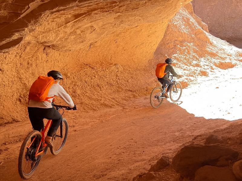
A slot of red rock barely wider than a vehicle, cut into the hills north of San Pedro. Most people arrive on a mountain bike, having ridden out through the Catarpe valley at 2,400 m, which is where the day gets interesting.
What is Garganta del Diablo, and where is it?
Garganta del Diablo, the Devil's Throat, is a narrow red-rock canyon in the hills north of San Pedro de Atacama, reached through the Catarpe valley. It is a dry watercourse cut into sedimentary rock, tight enough in places that the walls close in on both sides, and it is almost always visited by mountain bike from town.
The canyon itself is not enormous. That is the point. What makes it worth the ride is the transition: you cross open desert flats with the volcanoes on the horizon, drop into a green ribbon of valley where the San Pedro river actually runs, then enter a slot where the sky becomes a strip overhead and the temperature drops several degrees in the shade of the walls.
Geologically it belongs to the same story as the rest of the basin. These are sedimentary beds, laid down and later uplifted, then cut by water in periods far wetter than anything the region sees now. Today the channel is dry almost all the time. The floor is sand and gravel, the walls are layered red and ochre, and the erosion patterns tell you exactly how fast water once moved through here.
The route also passes Pukara de Quitor, the pre-Inca stone fortress on the hillside about 3 km from town, which is why the two appear together on almost every itinerary. You get archaeology, an oasis valley and a canyon in one morning.
Ride The Canyon With The Route Handled
Choose what you want and the time you can give it. The result explains the trade-off before you open the booking page.
How do you get there from San Pedro?
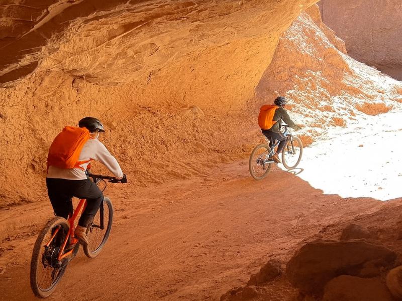
North out of town on the Quitor road, past the fortress, then into the Catarpe valley following the river, and up into the canyon. Guided bike tours cover the whole thing in about four hours including a river crossing and a stop at the ruins. The total riding distance is on the order of 20 km round trip depending on the route taken.
| Segment | Roughly what it involves | Surface | What to expect |
|---|---|---|---|
| San Pedro to Quitor | The first few kilometres out of town | Mixed surfaced and graded road | Flat, fast, warming up |
| Quitor to the Catarpe valley entrance | Past the fortress into the valley mouth | Gravel track, some loose sections | Gentle gradient, dust from passing vehicles |
| Catarpe valley floor | Following the San Pedro river corridor | Sand, gravel, occasional water crossing | Green tamarugo and chanar in a red valley, shade in patches |
| Approach to the canyon | Climbing gently toward the slot | Loose sand, corrugated in places | The section where soft sand costs the most energy |
| Garganta del Diablo | Into and through the narrow canyon | Firm sand and gravel between rock walls | Shade, echo, twisting turns, occasional dismounts |
| Return | Back the way you came or via a loop | As above | Hotter, and into headwind on many afternoons |
Doing it independently is possible: bike hire is easy to arrange in San Pedro and the route is not hard to follow in daylight. Two things argue for a guide anyway. The river crossing and the sandier sections are where inexperienced riders get stuck, and there is a real difference between a puncture 2 km from town and a puncture 10 km out with no shade and no phone signal. Practical hire information is in getting around San Pedro.
What does riding at 2,400 m do to your fitness?
Air pressure in San Pedro is roughly three quarters of sea level, so every hard effort costs you more and recovers slower. Fit riders typically lose something in the range of 10 to 20 percent of their sustainable output at this elevation. The route is not steep, but the thin air turns moderate sections into hard ones.
| Elevation | Approximate share of sea-level air pressure | What riders notice |
|---|---|---|
| Sea level | 100% | Baseline |
| San Pedro de Atacama, 2,400 m | about 75% | Higher breathing rate, slower recovery after every effort |
| Catarpe and the canyon, about 2,400 to 2,600 m | about 74 to 75% | Same as town, no additional altitude stress |
| El Tatio, about 4,300 m | about 59% | Walking pace only for most visitors |
| Cerro Toco, 5,604 m | about 50% | A guided climb, not a fitness ride |
The good news in that table is the third row. The canyon route does not climb into thin air, it stays at town elevation throughout. So this is a ride you can do on day two of a trip without waiting to acclimatise, which is unusual for an active Atacama outing.
What still catches people is the combination of altitude with dry air and heat. You will be breathing hard, and every breath in this climate takes moisture with it. Riders regularly finish this route more dehydrated than they realise because they never felt properly sweaty: the sweat evaporates before it registers. Drink on a schedule rather than by thirst.
If you arrived in San Pedro yesterday, give yourself an easy first day before this ride. The acclimatisation logic across the whole trip is in the altitude and tour order guide.
Bike, horse or on foot: which suits you?
The bike is the standard and the most efficient, covering the flats quickly and leaving energy for the canyon. Horseback covers the same Catarpe and Chulacao terrain at a gentler pace for non-cyclists. Walking the full route from town is possible but long and exposed, and few people choose it.
| Mode | Typical duration | Fitness required | Best for | Main limitation |
|---|---|---|---|---|
| Guided mountain bike | About 4 hours | Moderate, comfortable on gravel | Most visitors, and anyone wanting the canyon plus Quitor in one go | Soft sand and heat |
| Independent bike hire | 3 to 5 hours | Moderate, plus self-sufficiency | Confident riders with their own timing | Punctures, navigation, no support |
| Horseback riding | About 2 hours | Low, beginners accommodated | Non-cyclists, families, anyone who wants the valleys without pedalling | Shorter reach, does not always enter the canyon itself |
| Walking from town | Half a day or more | High, given heat and exposure | Hikers who start very early | No shade, long return, water weight |
| Canyoning day tour | About 6 hours | Moderate to high | People wanting rappels and water rather than a canyon ride | A different activity in different terrain |
The horseback option deserves a fair hearing. It runs about two hours through the Salt Mountains toward the Catarpe and Chulacao canyons and past a fossil area, with horses matched to rider level and instruction included, which makes it a reasonable pick for anyone who has not been on a bicycle in years. It is not a substitute for riding into Garganta del Diablo, but it puts you in the same landscape.
The Direct Fit And Useful Alternatives
Catarpe Valley And Devil’s Throat By Bike
Follow a guided cycling route through Catarpe and Devil’s Throat, with a bicycle and safety equipment provided. Pay for the route knowledge as well as the bike.
Meeting point in central San Pedro. Off-road riding; entry charges are separate.
Book on ViatorRide Devil’s Throat ↗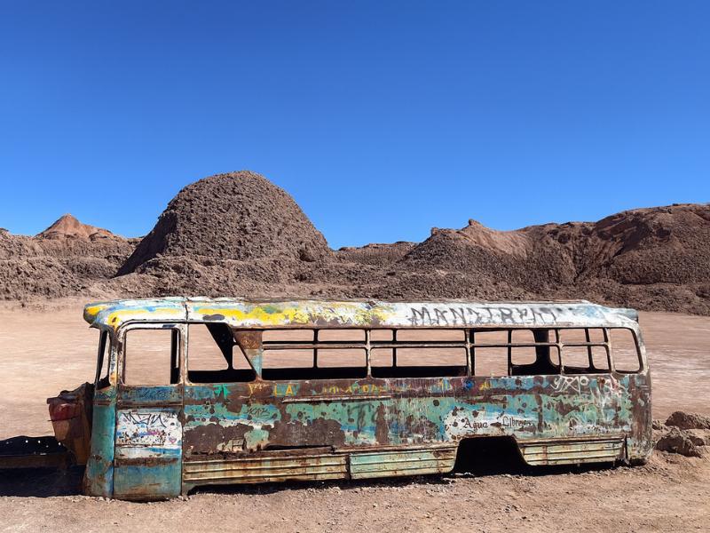
Vallecito And Magic Bus
Give your camera a different desert subject: Vallecito and the Magic Bus. The outing includes snacks, with pickup offered within the operator’s coverage.
Meeting point available outside the pickup area.
Book on ViatorSee The Magic Bus Outing ↗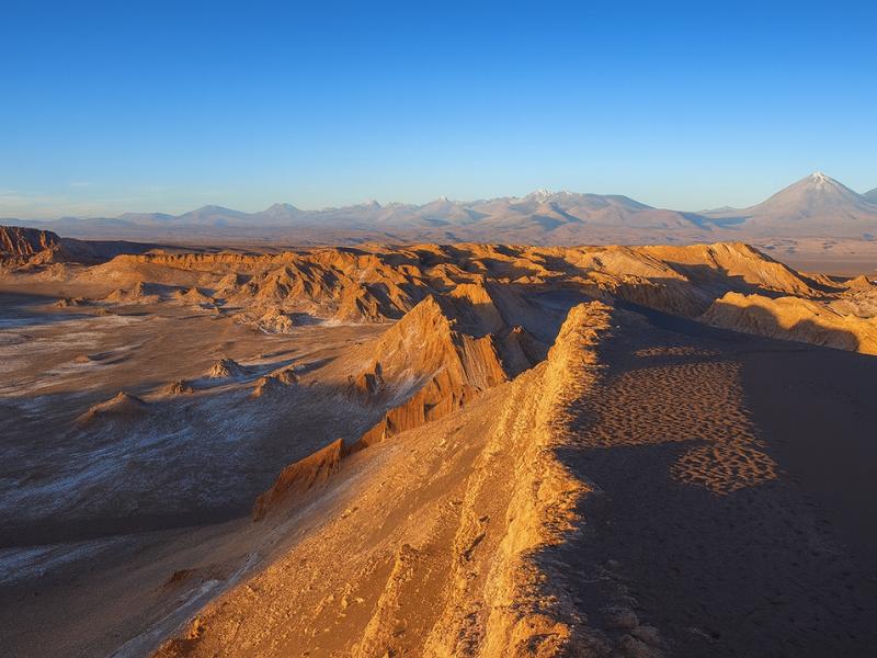
Valley Of The Moon
Make room for a desert landscape outing without committing several days. A guided Moon Valley excursion gives your afternoon a clear destination.
About four hours. Walking is involved; read the participation requirements.
Book on ViatorSee Moon Valley Departures ↗What are the surface conditions, and what ruins a ride?
Sand is the problem, not gradient. The route mixes graded gravel, corrugated track and stretches of soft sand where a front wheel washes out, plus at least one water crossing. Nobody falls off because the route is steep. People come off because they hit deep sand at speed with their weight forward.
- Soft sand. Keep your weight back, stay off the front brake, pick a firm line and keep pedalling. If the bike stops, walk it a few metres rather than fighting it.
- Corrugations. Washboard sections rattle everything loose. Check your bottle cage and any bag before you set off.
- River crossings. The San Pedro river runs shallow through Catarpe. Water level changes, and wet rocks are slippery. Guides usually walk groups across.
- Loose gravel on the descents. The canyon exit and some approach sections carry small stones over hard base, which is where the front wheel goes.
- Punctures. Thorny scrub grows along the oasis sections. This is the most common mechanical failure on the route by a wide margin.
- Dust from vehicles. Tour vans and pickups use the same tracks. Give them room and let the dust settle before riding through it.
Check your hire bike before leaving town rather than 8 km out. Brakes, tyre pressure, saddle height, and whether there is actually a pump and a spare tube in the kit. Reputable operators supply bike, helmet and tools as standard, and small-group formats mean a mechanical stop does not strand fifteen people in the sun.
How hot does it get, and how much water do you need?
Plan on at least two litres per person for a half-day ride, more in summer, and start early. There is no shade on the flats, no water source you should drink from, and nothing to buy between San Pedro and the canyon. Afternoon heat plus a headwind is what turns a pleasant ride into a grim one.
| Departure window | Conditions | Water to carry | Verdict |
|---|---|---|---|
| Early morning, soon after first light | Coolest air, low sun, still conditions | 2 litres | The best window, and what most guided tours use |
| Mid-morning | Warming fast, sun getting high | 2 to 2.5 litres | Workable, finish before midday |
| Midday to early afternoon | Peak heat, hardest light, no shade | 3 litres and honestly reconsider | Avoid, especially in summer |
| Late afternoon | Cooling, but daylight running out | 2 litres | Risky, you do not want to be in a canyon at dusk |
Two other things people underestimate here. Ultraviolet exposure at this elevation in clear desert air is severe, and a cycling jersey does not cover the backs of your hands, your neck or your ears. Sunscreen goes on before you leave and again halfway. And the relative humidity is often in single digits, which means you lose water with every breath as well as through skin.
Electrolytes are worth carrying if you sweat heavily. Plain water in large volumes on a hot dry ride can leave you feeling worse rather than better. A sachet in one bottle solves it.
Can you combine the canyon with Pukara de Quitor?
Yes, and most guided rides do. Pukara de Quitor sits on the route out of town, about 3 km from San Pedro, on the hillside above the river valley. Riders stop, climb to the viewpoint, then continue into Catarpe. It adds roughly an hour and it is the natural pairing.
The two sites work well together because they explain each other. Quitor is a fortified settlement built where the valley narrows, above the water. Ride on into Catarpe and you see exactly why: this corridor is the green line through an otherwise lifeless basin, and controlling it mattered. Standing on the fortress terraces looking down the valley you have just cycled makes the geography obvious in a way no display board can.
Expect a separate community-managed entry at Quitor. Do not assume it is bundled into your bike hire if you are riding independently, and carry some cash. What a visit involves in detail, including the climb and the history, is in the Pukara de Quitor guide.
Who should skip this, honestly?
Anyone who has not ridden a bike off tarmac in years, anyone in their first 24 hours at altitude, and anyone who dislikes heat and dust. The route is not technically difficult, but it is exposed, sandy and unforgiving of poor pacing, and there is no easy way to bail out halfway.
| Profile | Verdict | Better alternative |
|---|---|---|
| Regular cyclist, comfortable on gravel | Ideal, this is your morning | None needed |
| Occasional rider, reasonable fitness | Fine with a guide and an early start | Small-group guided ride |
| Has not cycled in years | Not recommended | Horseback ride through Catarpe and Chulacao |
| Just arrived at 2,400 m today | Wait a day | A Moon Valley afternoon instead |
| Travelling with young children | Generally too long and exposed | Horseback, or a short town-and-Quitor walk |
| Wants adventure but not a bike | Look elsewhere in the catalogue | Canyoning with rappels, or the balloon flight |
Our notes for families are in travelling with kids in Atacama and for older visitors in the senior travellers guide. Neither rules this ride out on age alone. Both suggest choosing the format honestly rather than optimistically.
Choose A Date For Your Outing
Catarpe Valley And Devil’s Throat By Bike
Select your date and party on Viator for the current price and departure options.
Ride Devil’s Throat ↗What should you wear and carry?
Closed shoes with grip, sun protection you can reapply, at least two litres of water and something over your face for the dust. Cycling kit is fine but not required. What matters is covering skin, keeping the sun off your head and being able to see when a vehicle passes.
- Helmet. Supplied on guided rides. If you hire independently, insist on one.
- Sunglasses. As much for grit and dust as for glare.
- Buff or light scarf. Pull it up when vehicles pass, which they will.
- Long sleeves in light fabric beat sunscreen on the arms over several hours.
- Two litres of water minimum, in bottles that stay put on corrugated track.
- Snack with salt in it. Most guided rides include breakfast, but carry something anyway.
- Small cash amount for the Quitor entry if you are riding independently.
- Phone, accepting that signal in the Catarpe valley and the canyon is unreliable.
Padded shorts are a genuine comfort upgrade on hire bikes, whose saddles are rarely the ones you would choose. And gloves are more useful than people expect on corrugated surfaces, where hours of vibration through the bars is what actually tires your hands. The full trip list is in the Atacama packing guide.
Which tours reach Devil's Throat and the surrounding canyons?
One tour in our catalogue rides directly to Garganta del Diablo. Two others put you in the same terrain differently: a horseback ride through the Catarpe and Chulacao canyons, and a full-day canyoning trip with rappels for people wanting a harder adventure day.
| Tour | Listed price | Rating | Duration | Bookings | What it covers |
|---|---|---|---|---|---|
| Desert Bike Tour: San Pedro to Devil's Throat | from $85 | 5.0 | 4 hours | 1,108+ | Catarpe valley trails, Pukara de Quitor, river oasis riding and the canyon descent. Bike, helmet and breakfast included, group capped at 6 |
| Horseback Riding Adventure with Scenic Views | from $68 | 4.5 | 2 hours | 617+ | Salt Mountains to the fossil area, Catarpe and Chulacao canyons, horse matched to your level, instruction and hotel pickup included |
| Desert Adventure Tour with Canyoning & Trekking | from $189 | 5.0 | 6 hours | 475+ | High-altitude hike plus four rappels down waterfalls into pools, all safety gear, expert guides, group capped at 15 |
Note the group cap of six on the bike tour. On a route where one puncture stops everybody, that number is doing real work. Those are listed starting prices and they shift with season, so check the live listing before booking. If you are still weighing guided against independent across the whole trip, see guided tours or self-drive.
Where does the canyon fit in an Atacama week?
Day two or three, in the morning, on a day when you are not also doing a high-altitude tour. It is an active half-day at town elevation, which makes it a good pairing with an easy afternoon and a poor pairing with a pre-dawn geyser start.
| Day | Morning | Afternoon or evening | Why it works |
|---|---|---|---|
| 1 | Arrive, rest, hydrate | Moon Valley sunset | No altitude gain on arrival day |
| 2 | Bike to Quitor and Garganta del Diablo | Easy evening, or a stargazing tour | Effort at town altitude, nothing above 2,600 m |
| 3 | Full day to the altiplanic lagoons and Piedras Rojas | Rest | By now you are adjusted enough for 4,000 m plus |
| 4 | Pre-dawn El Tatio geysers | Puritama hot springs or a free afternoon | The highest, coldest, earliest day goes last |
Stacking a hard ride onto the same day as a 4,300 m tour is the classic mistake. You will not enjoy either. Compare the shapes in the 3 to 4 day classic itinerary and five days in Atacama, and if you are short on days, the two-day plan shows what actually fits.
One last argument for this ride. Most Atacama activities happen through a van window with fixed stops. This one puts you in the landscape under your own effort, at your own pace, with dust on your legs and the volcanoes moving slowly across the horizon. For a lot of visitors it ends up being the day they talk about afterwards, and it costs less than most full-day tours. If low-cost, high-value days interest you, the rest are collected in budget-friendly activities in Atacama.
Make It Part Of Your Trip
The dedicated bike tour follows the canyon route and supplies the bike and safety equipment.
Catarpe Valley And Devil’s Throat By Bike
Follow a guided cycling route through Catarpe and Devil’s Throat, with a bicycle and safety equipment provided. Pay for the route knowledge as well as the bike.
Ride Devil’s Throat ↗