Valle de la Luna: The Complete Moon Valley Guide
Thirteen kilometres west of San Pedro, a dried lake bed of salt and clay has been folded upward and cut into ridges, dunes and caverns. Almost every visitor sees it on their first afternoon, and for good reason.
What exactly is Valle de la Luna?
Valle de la Luna is a basin of salt, gypsum and clay inside the Los Flamencos National Reserve, roughly 13 km west of San Pedro de Atacama. It sits in the Cordillera de la Sal at broadly the same altitude as the town itself, which makes it the closest large landscape to San Pedro and the easiest one to reach.
The rock under your feet is not ordinary desert stone. It began as the floor of a basin that filled and evaporated over and over across millions of years, leaving thick beds of halite, gypsum and fine clay. Tectonic pressure later squeezed those beds upward into a low range, the Cordillera de la Sal, which runs roughly north to south between the Salar de Atacama and the mountains to the west. Wind and the rare downpour have been carving it ever since.
What that produces is a landscape with no soil, no plants and no water, and with a surface that behaves oddly. Salt crusts crunch underfoot. Crystals grow in the shade of overhangs. On cool evenings the ground makes faint popping and ticking sounds as the salt contracts, which is the closest thing the valley has to wildlife noise. Chile's forestry service CONAF administers the reserve together with the Atacameña community of San Pedro de Atacama, and Los Flamencos is not a single block of land but several separate sectors scattered across the region, of which Moon Valley is only one.
The lunar comparison came from the shape of the ground rather than from any single rock. Nobody is claiming that any of it looks like a specific crater. The point is that the surface reads as geology without biology, which is rare on this planet, and the reason researchers keep coming back to the wider Atacama Desert as a stand-in for Mars.
Choose Your Valley Afternoon
Choose what you want and the time you can give it. The result explains the trade-off before you open the booking page.
Why is Moon Valley almost always your first tour?
Because it asks nothing of an unacclimatised body. Moon Valley sits at roughly the same 2,400 to 2,600 m as San Pedro, so there is no altitude gain to absorb, and it runs in the late afternoon, which fits a day you arrived on. Everything else on the Atacama menu climbs much higher.
This is the single most practical thing to understand about the region. San Pedro is already high. Most visitors arrive by air into Calama, at a similar elevation, or by bus from the coast, and the standard advice is to give yourself a day or two before you go above 4,000 m. Moon Valley is the tour that respects that, which is why operators put it on day one and why our team recommends the same order.
| Destination | Approximate altitude | Roughly what share of sea-level air pressure | Acclimatisation needed first? |
|---|---|---|---|
| San Pedro de Atacama (town) | 2,400 m | about 75% | No, but rest on arrival day |
| Valle de la Luna | about 2,400 to 2,600 m | about 75% | No |
| Vallecito and Cordillera de la Sal | about 2,400 to 2,600 m | about 75% | No |
| Pukara de Quitor | about 2,500 m | about 74% | No |
| Laguna Cejar | about 2,300 m | about 76% | No |
| El Tatio geyser field | about 4,300 m | about 59% | Yes, ideally after two days |
| Miscanti and Miniques lagoons | above 4,000 m | about 61% | Yes |
| Cerro Toco summit | 5,604 m | about 50% | Yes, several days |
Read the right-hand column carefully. The jump from Moon Valley to El Tatio is not a small step up, it is a change from three quarters of the oxygen you are used to down to under six tenths. Our full breakdown of the sequence lives in the altitude and tour order guide, and the practical consequences for the highest tours are covered in the El Tatio geysers guide.
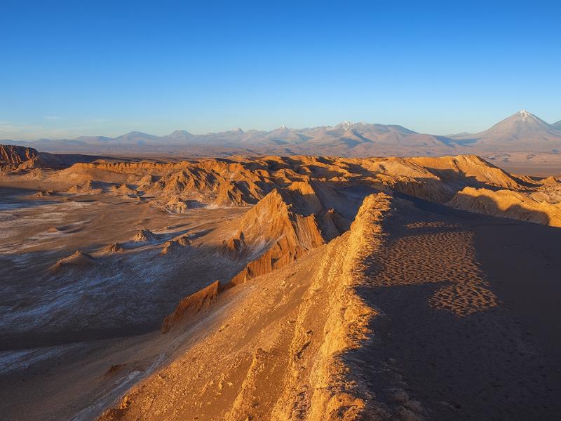
There is a second reason Moon Valley leads. It gives you the mental map. From the ridge above the valley you can see the Salt Mountains running away north and south, the Salar de Atacama shimmering east, and the cone of Licancabur standing over all of it. Once you have that picture, the rest of the week makes sense.
How do you get to Valle de la Luna from San Pedro?
Four ways: a guided afternoon tour with hotel pickup, a rented bicycle, a hired car, or a taxi. The reserve entrance sits about 13 km west of town along the road toward Calama, and the drive takes something like 20 to 30 minutes depending on where the tour stops first.
The guided option dominates for a reason that is more about the return than the outing. Sunset is the point of a Moon Valley afternoon, and sunset is also when the temperature drops fast and the light disappears. Riding a bicycle 13 km back into town in the dark, on an unlit road shared with tour vans, is a poor end to a good evening. Plenty of people do it. Fewer enjoy the last hour of it.
| How you go | Realistic outbound time | Best for | Main drawback |
|---|---|---|---|
| Guided afternoon tour | 20 to 30 min by van, with pickup | First-timers, sunset, anyone without a plan | You keep the group's schedule |
| Rented bicycle | 60 to 90 min each way for most riders | Fit riders visiting in the cooler morning hours | Return ride in the dark and cold |
| Rental car | About 20 min | Families, photographers, flexible timing | Unpaved sections, and you drive instead of looking |
| Taxi or private transfer | About 20 min | Small groups wanting control without driving | Arranging the pickup back at closing time |
If you are weighing the do-it-yourself version against a guide across the whole trip, the trade-offs are laid out in guided tours or self-drive. For bicycle hire, road conditions and the shuttle picture generally, see getting around San Pedro.
One point of honesty about self-driving: the surfaced road gets you close, but the internal reserve roads are graded gravel and washboard in places. A standard hire car manages it at low speed in dry conditions. It is not a place to be in a hurry, and mobile coverage inside the valley is patchy at best.
What do you actually see inside the reserve, stop by stop?
A typical guided afternoon covers four to five set pieces: the salt caverns, the Anfiteatro and the eroded ridge walls, the Gran Duna, the Tres Marias formations, and a sunset viewpoint on the ridge, usually Piedra del Coyote. Each stop is short, most involve some walking, and the order shifts with the season.
| Stop | What it is | Walking involved | Typical time there |
|---|---|---|---|
| Salt caverns | A tunnel system cut through salt and gypsum beds, narrow in places | Roughly 20 to 30 minutes underground, stooping and scrambling | 25 to 40 min |
| Anfiteatro and ridge walls | A curved wall of layered sediment showing the folding of the range | Short walk on level ground | 15 to 20 min |
| Gran Duna | A large sand dune banked against the valley wall, climbed on a ridge line | A steady climb on soft sand, several hundred metres | 30 to 45 min |
| Tres Marias | Three slender salt and clay figures standing alone on the flats | Flat, a few minutes from the road | 10 to 15 min |
| Piedra del Coyote | A ridge-top viewpoint over Valle de la Muerte and the salt range | Almost none, a short walk from parking | 40 to 60 min for sunset |
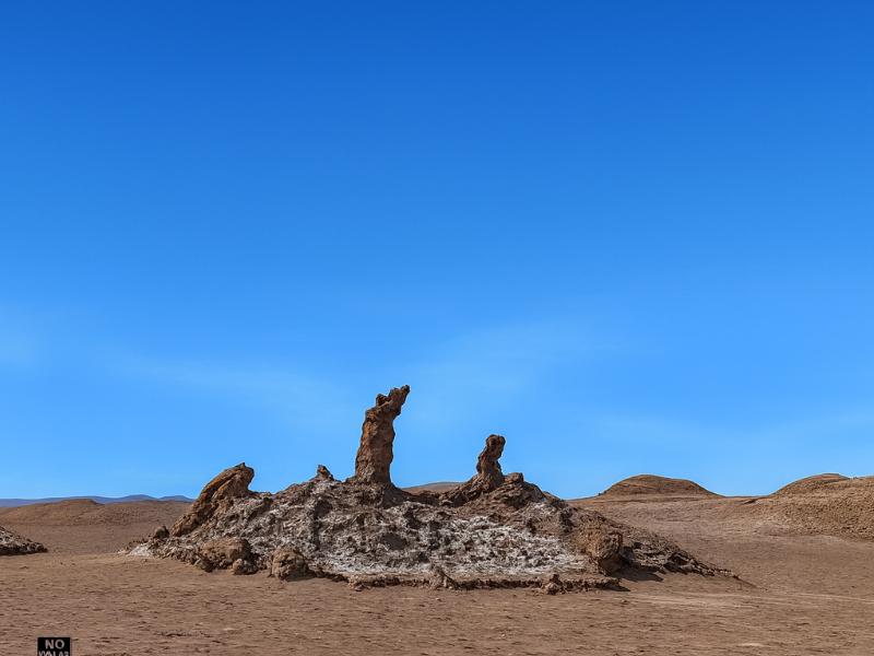
The Tres Marias deserve a note. They are small, they are fragile, and they are not what most people expect from a headline attraction. One of the figures was broken by a visitor who climbed on it, an incident widely reported in Chilean media, and the formations have been fenced and roped since. Look, photograph, keep your feet on the path.
Piedra del Coyote sits on the ridge road between Moon Valley proper and Valle de la Muerte, so it is technically the exit rather than the interior. It is also where most of the sunset happens, because it looks west over open ground with the Andes at your back going pink.
The Direct Fit And Useful Alternatives
Valley Of The Moon
Make room for a desert landscape outing without committing several days. A guided Moon Valley excursion gives your afternoon a clear destination.
About four hours. Walking is involved; read the participation requirements.
Book on ViatorSee Moon Valley Departures ↗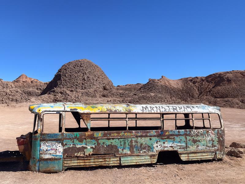
Vallecito And Magic Bus
Give your camera a different desert subject: Vallecito and the Magic Bus. The outing includes snacks, with pickup offered within the operator’s coverage.
Meeting point available outside the pickup area.
Book on ViatorSee The Magic Bus Outing ↗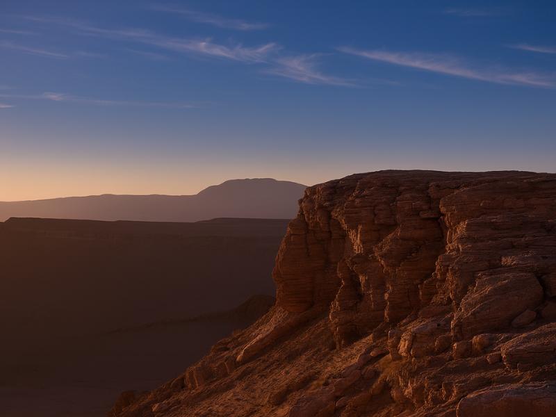
Atacama: 4 Tours In 3 Days
Spend your planning time on the rest of the trip. This package brings four outings into a three-day schedule, with accommodation pickup and a bilingual guide.
Entrance charges vary; accommodation is not included.
Book on GetYourGuideSee The 3-Day Tour Plan ↗How much walking is involved, and how hard is it?
Around 2 to 4 km in total across the afternoon, broken into short pieces, none of it technical. The Gran Duna climb is the only part that gets anyone breathing hard, and even that is a soft-sand slog rather than a scramble. Ordinary walking shoes handle everything except the caverns comfortably.
| Section | Approximate distance | Surface | Effort |
|---|---|---|---|
| Salt caverns passage | A few hundred metres | Uneven salt floor, low ceilings, dark | Moderate, awkward rather than hard |
| Anfiteatro loop | Under 1 km | Compacted gravel path | Easy |
| Gran Duna ascent | Several hundred metres up a ridge | Soft sand, exposed | The hardest part of the day |
| Tres Marias approach | A couple of hundred metres | Flat gravel | Easy |
| Sunset viewpoint | Minimal | Flat, roadside | Easy |
Soft sand at 2,400 m is deceptive. The gradient is not steep, but your feet sink, the air holds less oxygen than you are used to, and there is nowhere to stop in shade. People who run marathons at sea level still arrive at the top of the dune out of breath. That is normal and it is not altitude sickness. Slow down, breathe through it, and do not race the group.
Anyone with knee trouble, a fear of enclosed spaces or limited mobility can skip the caverns and the dune and still have a full afternoon: the viewpoints, the Tres Marias and the sunset are all near-flat. Guides are used to this and will tell you where the van will be. Our notes for older visitors are in the senior travellers guide, and for families in travelling with kids.
What happens at sunset, and how crowded does it get?
The last hour before sunset is when the valley turns from grey-brown to orange and red, and it is also when every operator in San Pedro converges on the same ridge. Expect a busy viewpoint with dozens of vehicles. The crowd is real, and it is not a reason to skip the tour.
Here is the honest picture. Moon Valley is the most-visited sector of the reserve, sunset is its peak hour, and San Pedro runs a lot of tour vans. The ridge viewpoints have room, but you will be sharing them. You will hear four languages within earshot. Somebody will be flying a drone until a guide stops them.
What makes it work anyway is the scale of what you are looking at. The view is not a single photogenic rock with a queue in front of it, it is an entire range of mountains and a salt flat changing colour. Walk 60 seconds along the ridge from where the vans park and the density drops noticeably. Turn around and photograph east while everyone faces west, because the Andes catch the pink alpenglow after the sun has gone and almost nobody is looking that way.
| Season | Character of the light | What it means for pickup | What to have with you |
|---|---|---|---|
| Midwinter, June and July | Sun drops early, sky often flawlessly clear | Operators shift pickup earlier in the afternoon | A proper insulated layer, hat and gloves |
| Shoulder, April to May and September to October | Long warm light, most reliable all round | Mid-afternoon pickup | Fleece plus a windproof shell |
| Midsummer, December to February | Late sunsets once daylight saving is in effect, occasional altiplanic cloud | Latest pickup times of the year | Sun protection early, one warm layer for after dark |
Sunset times swing by well over two hours across the year here, and Chilean daylight saving moves them again, so confirm the day's timing locally rather than assuming. The seasonal picture in full is in the best time to visit, with the month-by-month detail in the season comparison.
The temperature drop after sunset catches people out every single evening. The desert loses heat fast once the sun is off the ground, and a pleasant 25 C afternoon becomes a genuinely cold, windy ridge within half an hour. Bring the jacket you think you will not need.
Are the salt caverns worth doing, and what are they like?
Yes for most people, no for anyone claustrophobic. The caverns are a natural passage cut through salt and gypsum, tight enough in places that you crouch or turn sideways, dark enough that you need a torch, and roughly 20 to 30 minutes end to end. It is the most physical part of the afternoon and the most memorable.
The walls are not smooth rock. They are layered, crystalline and sharp in places, and the salt catches a headtorch beam in a way that photographs badly and looks extraordinary in person. In a few sections the ceiling drops to well under head height. There are steps and short scrambles. Guides go first and call out the low bits.
Practical points that matter more than they sound. Wear a hat or keep a hand up: the ceiling will find your head at least once. Do not wear anything you mind snagging, because salt crystals abrade fabric. A phone torch works but a headtorch is far better, since you want both hands. And if you have any doubt about tight spaces, say so at the start rather than halfway in, because turning around in a queue of twenty people is unpleasant for everybody.
Access to the cavern section is not guaranteed. CONAF and the community managing the reserve close sections for safety after rain or for maintenance, and no operator can promise it will be open on your date. Treat it as a likely bonus rather than the reason you booked.
What are the park rules, and why do they matter here?
Stay on marked paths, never climb on rock formations or dunes outside the designated route, take everything out with you, and follow the guide on drone use. The surfaces here are salt and clay, which means footprints do not blow away and broken formations do not grow back.
This is not a place where the environment repairs itself. Rain falls in this part of the Atacama on a scale of years, not weeks. A boot print pressed into salt crust can sit there for a very long time. A track cut across an untouched slope by somebody wanting a better photo becomes a permanent scar that the next fifty people follow. The reserve staff are not being fussy when they whistle at somebody who has stepped over a rope.
- Marked paths only. Where there are ropes, posts or a defined route, that is the route, including on the Gran Duna where the climb follows a specific ridge line.
- No climbing on formations. The Tres Marias are the cautionary tale, but it applies to every eroded pinnacle and overhang in the valley.
- Nothing comes home with you. Salt crystals, gypsum shards and clay fragments stay where they are. Removing geological material from a protected reserve is not a souvenir, it is a violation.
- Pack out all rubbish, including fruit peel, which does not decompose meaningfully in this climate.
- Drones are restricted. Ask your guide before you unpack one, and accept the answer.
- Closing time is enforced. The reserve clears visitors shortly after sunset. Do not plan to linger for astrophotography here, book a dedicated stargazing tour instead.
The reserve is co-managed with the Atacameña community, which means the rules are not only conservation policy, they reflect a relationship between local people and land they have lived alongside for a very long time. That is worth taking seriously in the same way you would at Pukara de Quitor.
Choose A Date For Your Outing
Valley Of The Moon
Select your date and party on Viator for the current price and departure options.
See Moon Valley Departures ↗How do you photograph Valle de la Luna properly?
Shoot the last 90 minutes of daylight and stay 20 minutes past sunset. The midday version of this landscape is flat and washed out. Low sun brings out the ridges, the layered walls and the colour in the clay, and the afterglow on the Andes to the east is the shot most people miss because they leave too early.
| Light phase | Roughly when | What to point the camera at | Practical note |
|---|---|---|---|
| Harsh afternoon | More than 2 hours before sunset | Wide shots of texture, cavern entrances, detail in shade | Contrast is brutal, expose for the highlights |
| Golden hour | Final 60 to 90 minutes | Ridge lines, the dune's edge, long shadows on the flats | The best window for people in the frame |
| Sunset | The moment itself | West over Valle de la Muerte and the salt range | Where the whole crowd is standing |
| Alpenglow | 10 to 25 minutes after | East, at Licancabur and the Andean wall going pink | Almost nobody is facing this way |
| Blue hour | 25 to 40 minutes after | Silhouettes, the first stars over the ridge | You may already be back in the van |
A few things that make a real difference. Dust gets everywhere, so change lenses as little as you can and keep the bag zipped. A polariser deepens the sky at this altitude to a degree that can look artificial, so use it sparingly. A phone in night mode handles the alpenglow better than most people expect. And if you want the valley without a crowd in the frame, the answer is not a longer lens, it is walking further from the car park.
Anyone hoping to shoot the salt range from above should look at the sunrise balloon flight, which floats over Moon Valley, Death Valley and the Salt Mountains and gives a perspective no ground viewpoint can. It is a different budget entirely and it flies at dawn, not dusk.
What should you bring for an afternoon in Moon Valley?
Layers, more water than feels necessary, real sun protection and a torch. The afternoon starts hot and exposed and ends cold and windy on a ridge, often within two hours, and there is nothing to buy inside the reserve.
| Item | Why | When it matters most |
|---|---|---|
| 1.5 to 2 litres of water per person | Humidity here is among the lowest anywhere, you dehydrate without sweating visibly | The whole afternoon, especially the dune |
| Warm mid-layer plus windproof shell | Temperature falls sharply within 30 minutes of sunset | The sunset viewpoint |
| High-factor sunscreen, reapplied | Thin air, high UV, reflective pale ground | Before sunset |
| Brimmed hat and sunglasses | Glare off salt crust is severe | Arrival through late afternoon |
| Closed walking shoes | Sand, salt crystals and uneven cavern floors | Dune and caverns |
| Headtorch or phone torch | The caverns are genuinely dark | Caverns, and the walk back to the van |
| Lip balm with SPF | Dry air splits lips fast at this altitude | Every day of the trip |
| Small snack | Most tours include something, but not a meal | Mid-afternoon |
Leave the good camera bag zipped between shots and skip open sandals entirely, because fine salt dust works into everything and sand in the caverns is unpleasant. The full trip kit list, including what genuinely matters at higher altitude, is in the Atacama packing guide.
Which Valle de la Luna tour fits you?
Three formats cover most visitors: a straightforward four-hour afternoon tour, a longer five-hour version with more stops, and a multi-day package that folds Moon Valley into a wider itinerary. All three run in the afternoon and end at sunset, and all include hotel pickup.
| Tour | Listed price | Rating | Duration | Bookings | Best for |
|---|---|---|---|---|---|
| Valley of the Moon Tour | from $35 | 4.7 | 4 hours | 1,221+ | The efficient classic: Gran Duna, Tres Marias, Piedra del Coyote, park entry included |
| San Pedro de Atacama: Valle de la Luna Tour | from $47 | 4.6 | 5 hours | 1,611+ | A longer afternoon with more ground covered and time at each stop |
| Multi-Day Experience in San Pedro | from $540 | 4.8 | 4 days | 1,830+ | Moon Valley sunset plus stargazing, Rainbow Valley, Laguna Cejar, Piedras Rojas and El Tatio |
Prices move with season and availability, so treat those figures as the listed starting point and check the live listing before you commit. If you are deciding between joining a group and going private, the honest comparison is in private tours versus group tours, and the question of booking ahead or on arrival is covered in booking in advance or on arrival.
One thing the multi-day packages solve that individual tours do not: sequencing. Left to their own devices, people book El Tatio for their second morning and feel terrible. A package that runs Moon Valley first and the high-altitude days later is doing you a favour whether you notice it or not.
How does Moon Valley fit into a wider Atacama itinerary?
Day one, late afternoon, arrival day if your bus or flight gets in before mid-afternoon. It costs you nothing in acclimatisation, it orients you geographically, and it leaves the mornings free for the tours that need an early start and a settled body.
| Day | Morning | Afternoon and evening | Altitude reached |
|---|---|---|---|
| 1 | Arrive, rest, walk the town, drink water | Valle de la Luna sunset tour | about 2,600 m |
| 2 | Pukara de Quitor and the Catarpe valley, or a lagoon half-day | Stargazing tour after dark | 2,300 to 2,600 m |
| 3 | Full day to Piedras Rojas and the altiplanic lagoons | Rest, early night | above 4,000 m |
| 4 | Pre-dawn departure for El Tatio geysers | Afternoon free, Puritama hot springs if you have energy | about 4,300 m |
That sequence climbs steadily rather than spiking, which is exactly what you want. Compare it against the fuller versions in the 3 to 4 day classic itinerary and five days in Atacama, and see how many days to spend if you are still deciding.
If Moon Valley leaves you wanting the same landscape with fewer people in it, the answer is the neighbouring sector: Vallecito and the Magic Bus run through the same salt range on a quieter road. And if you want to see the Cordillera de la Sal from ground level under your own power, the Devil's Throat bike route cuts into a canyon on the other side of town.
Make It Part Of Your Trip
Choose the dedicated valley tour and keep the remaining days independent.
Valley Of The Moon
Make room for a desert landscape outing without committing several days. A guided Moon Valley excursion gives your afternoon a clear destination.
See Moon Valley Departures ↗