Licancabur Volcano: The Cone You Photograph, Not Climb
Licancabur is the shape everyone remembers from San Pedro de Atacama: a near-perfect cone on the eastern skyline, catching the first pink light before the town does. Almost nobody who photographs it will ever stand on top of it, and that is fine.
Can you climb Licancabur from San Pedro de Atacama?
Not as a tourist day trip, and not through this site. We do not sell a Licancabur summit climb. The normal ascent is organised from the Bolivian side, from the Laguna Verde area, and it is a serious high-altitude undertaking that takes a full expedition day with an early start, not a morning excursion.
This is the first thing to be straight about, because a lot of visitors arrive assuming otherwise. The mountain is right there. It looks climbable from the plaza. Trekking companies in town sell volcano ascents. Put those three facts together and the natural conclusion is wrong.
Two things stand in the way from the Chilean side. The first is the border itself: the summit sits on the frontier between Chile and Bolivia, and the Chilean flank carries a documented legacy of border minefields laid during the tense years of the 1970s. Demining work has gone on for decades in the wider border region, but the practical result is that the standard, established route runs up the Bolivian side. The second is simply the mountain. From a base near 4,300 metres you climb over 1,500 vertical metres of scree and volcanic rubble to nearly 5,916 metres, usually starting in the dark, in cold that has nothing to do with the warm desert town below.
If your goal is to stand on a high Andean summit while you are here, the honest answer is Cerro Toco, which reaches 5,604 metres from a very high trailhead and is sold as a guided day climb. If your goal is to see Licancabur properly, this guide is about exactly that.
| Licancabur key facts | Detail |
|---|---|
| Summit altitude | About 5,916 m |
| Location | On the Chile and Bolivia border, north east of San Pedro de Atacama |
| Form | Stratovolcano with a strikingly symmetrical cone |
| Summit feature | A crater lake near the top, among the highest lakes anywhere |
| Immediate neighbour | Juriques, about 5,700 m, the blunt cratered cone beside it |
| Normal climbing side | Bolivia, staged from the Laguna Verde and Laguna Blanca area |
| Sold as a climb here | No |
| Seen from | Almost everywhere around San Pedro, best on specific tours listed below |
Photograph The Landscape Or Plan A Different Summit
Choose what you want and the time you can give it. The result explains the trade-off before you open the booking page.
How high is Licancabur and what is the summit crater lake?
Licancabur stands at about 5,916 metres and holds a small lake inside its summit crater, one of the highest bodies of standing water on the planet. It stays liquid under ice cover through extreme cold, and scientists have studied it as an analogue for conditions on early Mars.
The lake is the detail that fixes this mountain in people's minds once they hear about it. A shallow pool a few hundred metres across, sitting inside a crater at nearly 5,900 metres, in air that carries under half the oxygen of sea level, exposed to some of the strongest ultraviolet radiation measured anywhere on earth. Life persists in it anyway, in the form of microorganisms adapted to conditions that would sterilise most environments.
That combination of extreme altitude, extreme UV and liquid water is why research expeditions have visited the crater repeatedly. It is not a place you can casually go and look at. Reaching the lake means completing the full ascent, which brings you back to the same practical problem: the climb is an expedition, staged from Bolivia, with acclimatisation built in.
The cone shape is worth understanding too. Licancabur is a stratovolcano, built up in layers of lava and fragmented rock from repeated eruptions, which is what produces that textbook triangular profile. Its neighbour Juriques, sitting immediately to its south east, shows what happens when the top of such a cone collapses or is blown open: a blunt summit with a visible crater notch. Seen together from the desert floor, the pair is a geology lesson you can take in at a glance.
| Peak | Approximate height | Shape | Visible from San Pedro |
|---|---|---|---|
| Licancabur | About 5,916 m | Near-symmetrical cone | Yes, dominant on the eastern skyline |
| Juriques | About 5,700 m | Truncated cone with an open crater | Yes, immediately beside Licancabur |
| Sairecabur | About 5,970 m | Complex ridge, higher but less shapely | Partly, to the north |
| Cerro Toco | 5,604 m | Rounded cone on the Chajnantor edge | Not prominently from town |
| Lascar | About 5,592 m | Elongated, multiple craters | Not from town, seen from the highland circuits |
Why is the ascent organised from the Bolivian side?
The established route runs from Bolivia because the Chilean flank carries a minefield legacy from 1970s border tensions, and because the Bolivian approach from the Laguna Verde area starts higher and follows a known line. It is a full expedition day, not a tourist excursion, typically beginning long before dawn.
Practically, climbers reach the Bolivian side as part of the Uyuni and Sud Lipez route, which crosses the border near Hito Cajon and passes Laguna Verde at around 4,300 metres. From there the ascent is long, cold and unrelentingly steep, on ground that gives way underfoot in the classic volcanic manner. Guides are required, permits and border formalities apply, and the weather window matters enormously.
It also demands real acclimatisation. Anyone attempting a 5,900 metre summit should have spent days at altitude beforehand, and the Bolivian altiplano route conveniently provides that, since travellers on the Uyuni crossing have usually been sleeping above 3,600 metres for several nights already. Travellers considering combining the two countries can read our comparison of the Atacama and the Uyuni salt flats, which covers how that crossing works.
| Aspect | From Bolivia (the normal route) | From Chile |
|---|---|---|
| Typical base | Laguna Verde area, around 4,300 m | San Pedro de Atacama, about 2,400 m |
| Vertical gain to summit | Roughly 1,600 m | Roughly 3,500 m from town level |
| Route status | Established, guided | Not a standard tourist route |
| Border minefield legacy | Not on the standard line | Documented history on parts of the frontier flank |
| Acclimatisation | Usually built in by the Uyuni crossing | Would need days of deliberate preparation |
| Sold by this site | No | No |
| Realistic for a normal holiday | Only with expedition planning | No |
We would rather say this plainly than let a page imply otherwise. If a company in town offers you a Licancabur summit from the Chilean side, ask hard questions about the route, the border and the permits before you hand over money.
What does Licancabur mean to the Atacameno people?
Licancabur is a sacred mountain to the Lickanantay, the Atacameno people of this desert, and has been a ceremonial site for far longer than tourism has existed here. Archaeological remains near the summit show that people made the ascent in pre-Hispanic times, at altitudes that would challenge a modern climber with equipment.
The name itself comes from Kunza, the ancestral language of the Atacameno communities, and is commonly glossed as something close to "mountain of the people". Kunza is no longer spoken as a living everyday language, though words and place names survive throughout the region, and community efforts to recover it continue.
Mountains in this part of the Andes are not scenery in the local understanding. They are presences with names and relationships, tied to water, to the flow of meltwater into the oases, and to the agricultural calendar of villages like Toconao and Socaire. When you visit Toconao or Socaire on a highland circuit, you are in settlements whose entire existence depends on water coming off these volcanoes.
Pre-Hispanic and Inca-era ceremonial structures have been documented high on Licancabur, part of a wider Andean pattern of high mountain ritual sites. That people carried out ceremonies at close to 5,900 metres, without modern clothing or equipment, tends to recalibrate how visitors think about the mountain. It is not an unclimbed peak. It is a peak that was climbed for reasons that had nothing to do with sport.
Treating the volcano as a summit to be collected misses what it is to the communities living beneath it. Looking at it well is not a lesser experience than standing on it.
The Direct Fit And Useful Alternatives
Valley Of The Moon
Make room for a desert landscape outing without committing several days. A guided Moon Valley excursion gives your afternoon a clear destination.
About four hours. Walking is involved; read the participation requirements.
Book on ViatorSee Moon Valley Departures ↗Cerro Toco Guided Summit Day
A mountain guide and transport from San Pedro for a demanding summit outing. This is a hiking day, distinct from a viewpoint stop on a sightseeing circuit.
Provider asks you to contact them before booking. Acclimatization and suitability need discussing; no summit guarantee.
Book on GetYourGuideReview The Cerro Toco Climb ↗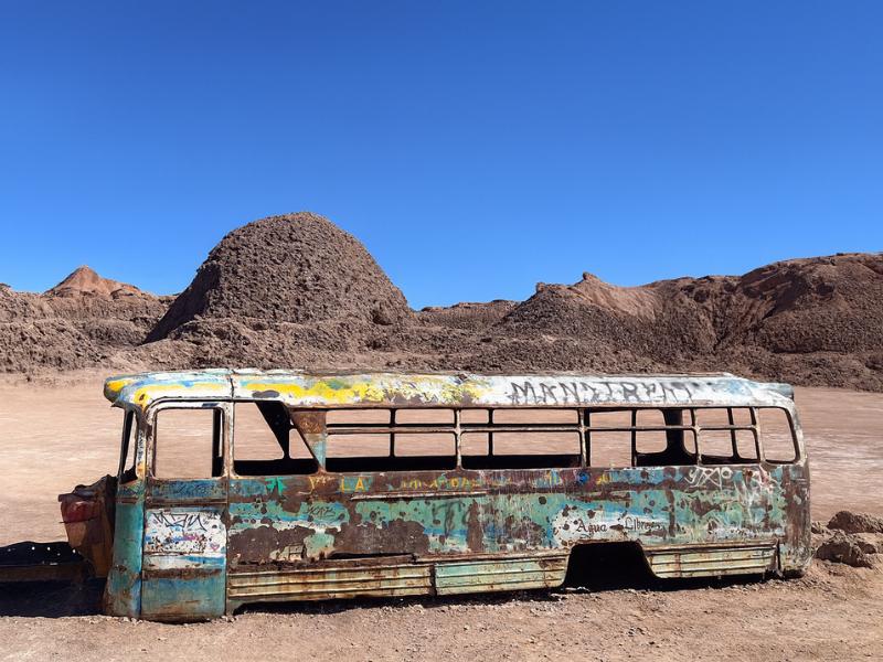
Vallecito And Magic Bus
Give your camera a different desert subject: Vallecito and the Magic Bus. The outing includes snacks, with pickup offered within the operator’s coverage.
Meeting point available outside the pickup area.
Book on ViatorSee The Magic Bus Outing ↗Where do you get the best view of Licancabur?
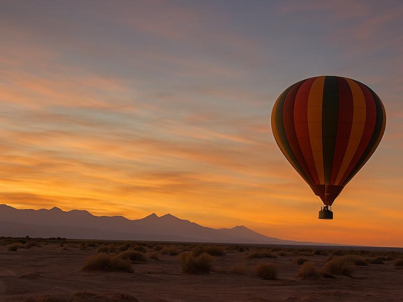
The best views are from the air at sunrise, from Valle de la Luna as the sun goes down, from the road up to the altiplanic lagoons, and from the summit of Cerro Toco. Each gives you a different mountain: silhouetted, side-lit, distant across the salt flat, or almost at eye level.
Licancabur is visible from most of San Pedro, so nobody misses it entirely. The difference between seeing it and photographing it well comes down to light and position. Because the volcano stands north east of town, the sun rises roughly behind it and sets behind you, which means dawn gives you a silhouette and dusk gives you a lit face. Understanding just that one relationship will improve your photographs more than any equipment will.
| Viewpoint | Approximate altitude | Best light | What you get | Tour that goes there |
|---|---|---|---|---|
| From a balloon at sunrise | Launch about 2,400 m, floating above | First light | The cone above a shadowed desert, no crowds, no foreground clutter | Sunrise balloon flight |
| Valle de la Luna viewpoints | About 2,500 to 2,600 m | Late afternoon and sunset | Warm side-light on the cone with lunar rock in the foreground | Valley of the Moon tour |
| Cerro Toco summit | 5,604 m | Late morning | Near eye-level view across to the cone, the rarest angle | Cerro Toco climb |
| Salar de Atacama and Chaxa | About 2,300 m | Early morning | The volcano reflected beyond flamingos and salt crust | Highland circuit day tours |
| Road to the altiplanic lagoons | 3,500 to 4,300 m | Mid morning | The cone shrinking behind you as you gain height | Piedras Rojas and lagoons full day |
| San Pedro village edges | About 2,400 m | Dawn | Free, easy, the classic postcard | None needed, walk east at first light |
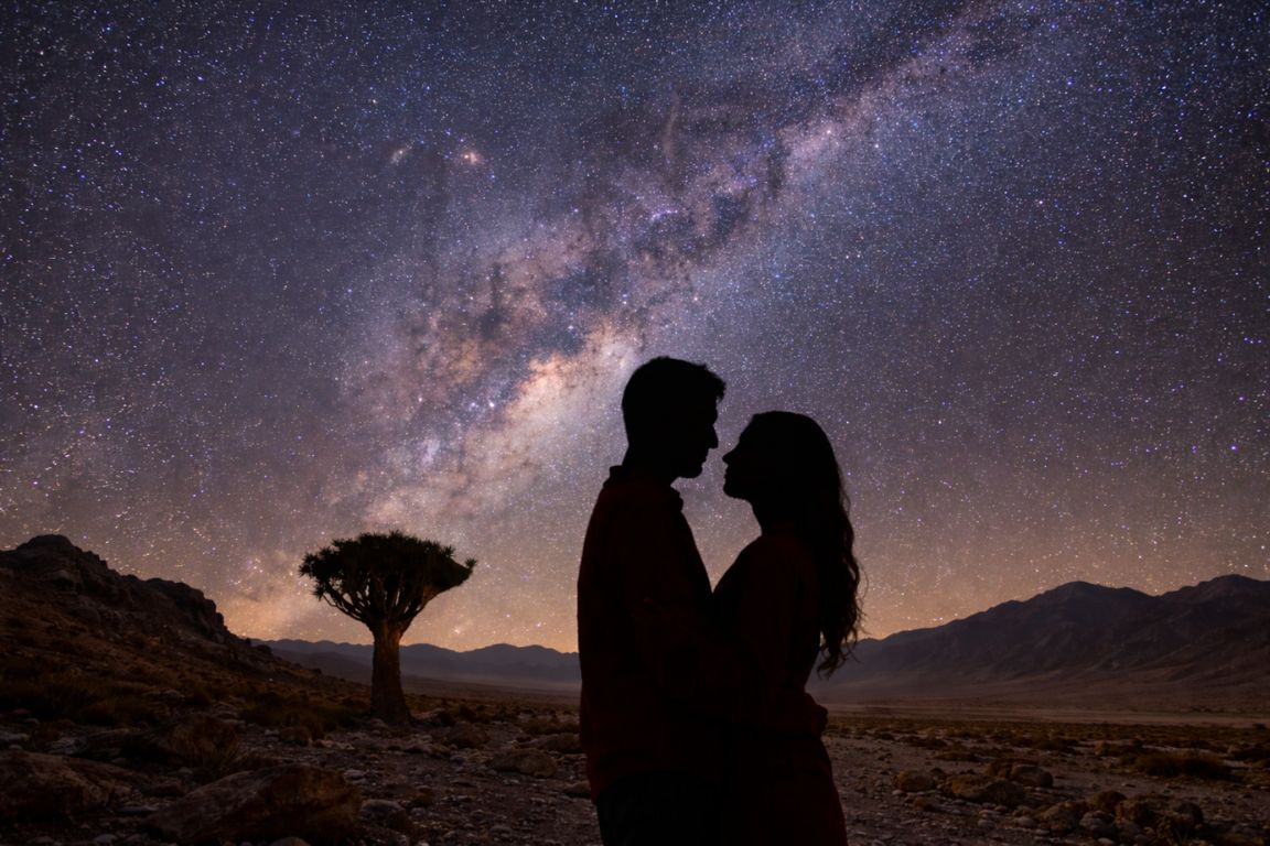
| Stargazing sites outside town | About 2,400 to 2,600 m | After dark | Black silhouette under the Milky Way | Evening astronomy tours |
The free option deserves its own mention. Walk to the eastern edge of San Pedro before sunrise, with a coffee, and you will watch the cone go from grey to rose to gold over about fifteen minutes. It costs nothing and beats a great many paid experiences.
Is the sunrise balloon flight worth it for Licancabur views?
For photographers and for anyone who wants the mountain without a crowd in the frame, yes. The sunrise balloon flight is listed at $350 for about three hours with a maximum of six passengers, rated 4.6 across 1,005 or more bookings. It floats over Moon Valley and the Salt Mountains with Licancabur on the horizon.
It is the most expensive way to look at this volcano, and it is also the only one that lifts you off the desert floor. From the basket you see the cone rising over a landscape still in shadow, with the salt ranges catching light in ridges below you. The horizon line is uninterrupted. There is no viewpoint car park, no other group, no fence.
The practical case for it is narrow but real. If you have one splurge in your Atacama budget and you care about photographs, this is a stronger candidate than a private version of a tour you could do in a group. If your budget is tight, the same mountain at the same hour from the edge of town is free, and our budget-friendly Atacama activities guide covers more of that thinking.
Altitude is a mild consideration rather than a barrier. Launch is near San Pedro's own 2,400 metres and the balloon floats a few hundred metres above the desert floor, so this is not a high-altitude activity in the way the geysers or the lagoons are. The early start in cold pre-dawn air is the harder part for most people.
| Consideration | Balloon flight | Free dawn walk east of town |
|---|---|---|
| Cost | Listed at $350 | Nothing |
| Duration | About 3 hours including breakfast | Thirty minutes if you want |
| Group size | Maximum six | Yourself |
| Angle on Licancabur | From above the desert floor, clean horizon | Ground level, some foreground buildings |
| Altitude load | Low, launch around 2,400 m | None |
| Weather sensitivity | High, wind cancels flights | None |
| Best for | Photographers, special occasions | Everyone, every morning |
How does Valle de la Luna frame the volcano at sunset?
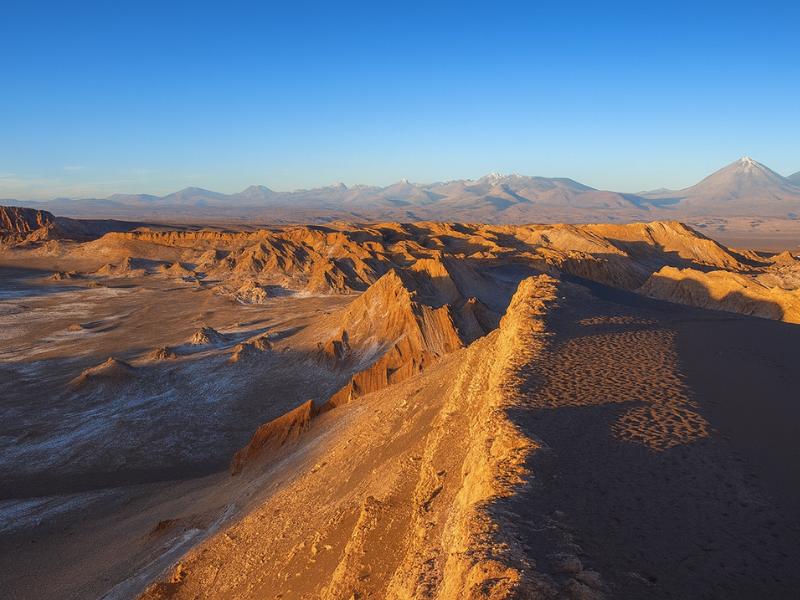
Valle de la Luna sits west of San Pedro, so at sunset you are looking back east toward Licancabur with the sun behind you. The cone lights up warm while the salt ridges in front of it fall into shadow. It is the single best land-based composition of this mountain, and the tour costs a fraction of the balloon.
The geometry does the work. From viewpoints along the Cordillera de la Sal, the foreground is eroded salt and clay in bands of ochre and grey, the middle distance is the flat desert floor, and the background is the volcano. As the sun drops, the colour temperature climbs and the cone turns from grey-blue to pink to a deep rust in the last few minutes. The Gran Duna and Piedra del Coyote viewpoints are the classic spots, and the Valley of the Moon evening tour, listed at $35 across about four hours and rated 4.7 from 1,221 or more bookings, is built around exactly this timing.
There is a trade-off to accept. These viewpoints get busy at sunset, and you will be sharing them. If crowds bother you, the Vallecito and Magic Bus route through the same salt range is quieter, and the volcano is still on the horizon.
Bring more clothing than the afternoon temperature suggests. The desert loses heat fast once the sun goes, and standing still on an exposed ridge in a light breeze at 2,600 metres gets cold quickly. Our Valle de la Luna guide has the full timing and viewpoint breakdown.
What do you actually see from Cerro Toco?
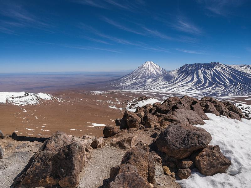
From Cerro Toco's 5,604 metre summit, Licancabur sits to the north at nearly the same height as you, which is an angle almost no visitor gets. The cone loses the towering quality it has from town and becomes one peak among many on a vast volcanic skyline.
It is a genuinely different experience of the same mountain. From San Pedro, Licancabur dominates because you are 3,500 metres below it. From Toco you are only about 300 metres lower, and what impresses instead is how many other volcanoes there are, stretching along the border in both directions with the Chajnantor antennas spread below.
Getting that view means earning it. The Cerro Toco climb is listed at $150 over about seven hours, rated 5 across 471 or more bookings, with trekking poles, helmet and trail snacks included. The walking is short, roughly 400 vertical metres from a very high trailhead, but the altitude is severe and several days of acclimatisation beforehand are what decide whether you enjoy it. The full breakdown is in our Cerro Toco climb guide.
| Where you stand | Height difference to Licancabur summit | How the mountain reads |
|---|---|---|
| San Pedro plaza, about 2,400 m | About 3,500 m below | Towering, dominant, the defining shape of town |
| Valle de la Luna viewpoint, about 2,600 m | About 3,300 m below | Distant and lit, a background element in a wide scene |
| Balloon at sunrise, a few hundred metres up | Roughly 3,000 m below | Clean horizon, cone above shadowed desert |
| El Tatio geysers, about 4,300 m | About 1,600 m below | One of several volcanoes on a high skyline |
| Cerro Toco summit, 5,604 m | About 300 m below | Near eye level, part of a volcanic chain |
Choose A Date For Your Outing
Valley Of The Moon
Select your date and party on Viator for the current price and departure options.
See Moon Valley Departures ↗Which other tours put Licancabur in the frame?
The highland circuit days give you the volcano from the salt flat and from the climbing road, the stargazing tours give you it as a silhouette under the Milky Way, and the horseback and bike routes through the Catarpe area put it behind red rock. There is no tour where you cannot see it, only tours where it is better placed.
On the full-day highland circuits, the volcano is behind you for most of the drive, which sounds like a drawback and is not. Stop at Chaxa in the morning for the flamingos and the cone is across the salt flat, occasionally mirrored in shallow water. Our Chaxa flamingos guide covers that stop properly.
Evening astronomy tours use sites outside town chosen for darkness, and on clear nights the volcano appears as a black wedge cut out of the star field. It is not what you booked the tour for, and it is often what people remember. More on that in our Atacama astronomy guide.
| Tour | Listed price | Duration | Licancabur view |
|---|---|---|---|
| Sunrise balloon flight | $350 | About 3 hours | Best overall, from the air at first light |
| Valley of the Moon | $35 | About 4 hours | Best value, warm sunset light on the cone |
| Cerro Toco climb | $150 | About 7 hours | Rarest angle, near eye level |
| Piedras Rojas and altiplanic lagoons | $110 | About 10 hours | Across the salt flat, then receding as you climb |
| Horseback riding in the Salt Mountains | $68 | About 2 hours | Framed by canyon walls near Catarpe |
| Roofless stargazing | $45 | About 2 hours | Silhouette beneath the Milky Way |
How do you photograph Licancabur well?
Shoot it at either end of the day and never in the middle. Dawn puts the sun behind the cone for silhouettes and rim light, late afternoon lights the western face warm. Midday flattens it into a hazy grey triangle that no amount of editing rescues.
A few practical points that make a real difference. Use a foreground: salt ridges, a line of tamarugo trees, adobe walls, the shore of a lagoon. The cone alone against sky is a shape without scale, and scale is the whole point of a 5,916 metre volcano. Second, watch for haze, which builds through the day and is heaviest in the Bolivian winter months of January and February. Third, a moderate telephoto compresses the mountain against the foreground and usually beats a wide angle, which shrinks it to a bump on the horizon.
| Time of day | Light on the cone | Best from | Verdict |
|---|---|---|---|
| Pre-dawn | Blue, cold, stars still out | East edge of town, stargazing sites | Excellent for silhouettes |
| Sunrise | Pink to gold rim light | Balloon, east edge of town | The strongest hour |
| Mid morning | Flat and bright | Chaxa, highland road | Workable with a foreground |
| Midday | Hazy, contrastless | Anywhere | Avoid |
| Late afternoon | Warming, lit western face | Valle de la Luna, Vallecito | Very good |
| Sunset | Deep rust, short window | Valle de la Luna viewpoints | The best land-based light |
| After dark | Black wedge under stars | Astronomy tour sites | Excellent with a tripod |
When is the mountain clearest through the year?
April to November gives the cleanest air and the highest chance of a sharp cone against deep blue. December to March brings the Bolivian winter, when moisture pushes over the Andes and cloud builds on the high peaks through the afternoon, sometimes hiding the summit completely.
The pattern surprises people, because the wet season here is the southern summer rather than the winter. Rain in San Pedro itself remains rare, but the volcanoes catch what falls, and a cone under cloud from noon onward is common in January and February. Those same months put snow on the summit, which many photographers actively want, so the trade is real rather than one-sided.
Winter, from June to August, is the clearest and coldest. Skies are consistently deep and the mountain reads sharply from dawn to dusk. Nights drop well below freezing and the days are short, which affects tour timings more than it affects visibility. Our best time to visit the Atacama guide weighs all of this against crowds and pricing.
| Months | Air clarity | Snow on the cone | Afternoon cloud risk | Verdict for views |
|---|---|---|---|---|
| December to February | Variable, hazy spells | Likely | High | Dramatic when clear, unreliable |
| March to May | Improving to excellent | Possible early on | Low | Very good, quieter season |
| June to August | Excellent | Occasional | Very low | The clearest window, coldest days |
| September to November | Excellent, windier | Rare | Low | Very good, strong afternoon wind |
What should you do instead of climbing it?
Do the three tours that show you the mountain best and, if you want a summit, climb Cerro Toco. That combination gives you Licancabur from the air, from the desert floor at golden hour and from near its own height, which is more of the mountain than most people who climb it ever see.
A sensible three-part plan looks like this. Early in your trip, when altitude is still settling, take the Valley of the Moon evening tour for the sunset composition. Mid trip, once you have a high-altitude day behind you, consider the sunrise balloon flight if the budget allows. Late in the trip, properly acclimatised, take the Cerro Toco climb.
That sequence is deliberate, and it follows the low-to-high logic set out in our altitude and tour order guide. Book them in the wrong order and the summit day, the expensive one, is the one that suffers.
| Trip stage | Tour | What it gives you | Altitude load |
|---|---|---|---|
| Days 1 to 2 | Valley of the Moon at sunset | The classic lit cone from the salt ranges | Low, about 2,600 m |
| Days 2 to 3 | Sunrise balloon flight | The cone from the air, clean horizon | Low, launch about 2,400 m |
| Days 3 to 4 | Highland lagoons circuit | Volcano across the salt flat, and real altitude practice | High, above 4,000 m |
| Day 5 or later | Cerro Toco climb | Licancabur at near eye level | Extreme, 5,604 m |
Framed that way, not climbing Licancabur stops feeling like a compromise. You get four distinct versions of the same mountain across a week, and you spend your energy on a summit that a guided day trip can actually deliver.
Make It Part Of Your Trip
Choose Moon Valley for its desert landscape; visibility and light determine the skyline on the day.
Valley Of The Moon
Make room for a desert landscape outing without committing several days. A guided Moon Valley excursion gives your afternoon a clear destination.
See Moon Valley Departures ↗